


A Kid-Friendly Visitor Guide to Hidden Yosemite
Two Perfect Days Exploring Hidden Gems and Glamping in Mariposa County


Yosemite’s grandeur is no secret—the roar of Yosemite Falls, the towering face of El Capitan, and the iconic Tunnel View draw millions every year. And while countless guides highlight these unforgettable landmarks, they often overshadow Yosemite’s quieter side: hidden waterfalls, secluded swimming holes, and peaceful trails where you might not see another soul.
I wanted to offer something different—inspiration for a more personal adventure, where the crowds thin out and the magic feels like it’s just for you. That’s why I always recommend starting in Mariposa County—Yosemite’s gateway to charm, hidden gems, and trails you'll never forget. It’s the kind of trip you’ll always remember—and never regret.
PS: If you love discovering California’s best hidden spots, subscribe to my 5-trail monthly newsletter and don’t miss part 2 of my Hidden Yosemite guide!
Now, let’s dive into the perfect Yosemite itinerary for families who love nature, crave that wow factor, and prefer fewer crowds. You can find a video overview on my Instagram, Facebook, and TikTok feeds.
Before You Go
📅 Yosemite reservations required for peak hours (6am–2pm) from June 15 to August 15 + Memorial and Labor Day weekends. Book starting May 6 via recreation.gov.
🗺️ Pack a printed map or download offline maps.
🧺 Don’t forget:
Sunscreen & hats
Bug spray (yes, even in Yosemite!)
A good attitude for long hikes — and a towel for swim breaks!
🛌 Where to Stay: AutoCamp Yosemite (Mariposa County)

Why you’ll love it:
Imagine roasting marshmallows under the stars after a long day of hiking, then curling up in a cozy bed inside a vintage Airstream — that’s AutoCamp Yosemite. It’s luxury meets campfire charm.
🌲 Family Perks:
Pool (open April–October), board games, and trails on-site
Nightly campfires (buy compressed wood at the Clubhouse)
Yoga, live music, and fireside chats
Dog-friendly, and the Clubhouse sells s’mores kits!
🍽️ Tip: Grab granola bowls from The Kitchen before hitting the trails.
Note: The following two day trips have pre-loaded google map links at the bottom of the blog!
Day 1: Wildflowers, Secret Tunnels & Hidden Waterfalls
Kick off your trip by stopping at High Country Health Foods & Cafe in Mariposa for healthy snacks, fresh fruit, and a solid grab-and-go sandwich for the trail.
Enter Yosemite via the El Portal Gate (Integrated map below)
🌸 Hike 1: Hite Cove Trail (Spring Wildflower Heaven)

📍 Near Redbud Lodge on Hwy 140
🅿️ Free street parking (very limited — arrive early)
🚽 Porta potty at the trailhead
🥾 Hike Distance: 6.5 miles out & back (best flowers in first 2.5 miles!)
⛰️ Elevation Gain: 1,000 ft (rolling terrain)
👶 Kid-friendly: Yes (pack water and snacks)
🐍 Warning: Rattlesnakes possible — stay on trail
💡 Pro Tip: Flowers open around 10am. Go 0.75 miles further to find old mining ruins!
💦 Hike 2: Wildcat Creek Falls

🥾 Trail: Unnammed / unofficial to bottom of Wildcat Creek Falls.
🗺️ Not on AllTrails
📍 Short trail entry on El Portal Rd just west of the Cascades Viewpoint
📏 Hike Distance: 0.3 miles out & back
⛰️ Elevation Gain: 25 ft.
🅿️ Parking: Very limited, small pull out at these coordinates: 37.721822, -119.715087. Bathrooms at alternative lot here.
🚫 Warning: No dogs.
💡 Pro Tip: Wear sun protection — the trail is fully exposed. Don’t attempt the rope-assisted crossing unless experienced (continue past the main falls by another 1 mile)
🕳️ Stop 3: Secret Tunnel Cave with a View of El Cap
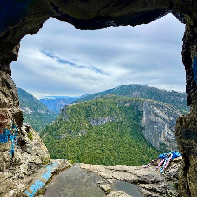
📍 Just before exiting Big Oak Flat Tunnel into Yosemite Valley
🗺️ No Alltrails for this one!
🅿️ Small pullout lot on the right side. Enter these coordinates into google maps: 37.717823388751576, -119.72266892467411.
👟 Walk ~0.1 miles inside the tunnel on the sidewalk
🔦 Pro Tip: Bring a flashlight or headlamp
📸 Photo Op: Look for a narrow cave halfway in for an unreal view of El Capitan
🚫 Respect: No graffiti or carving — protect this hidden gem!
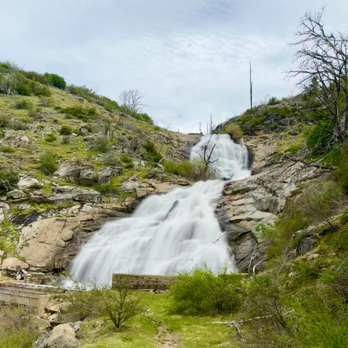
💦 Hike 4: Foresta Falls via Coulterville Road

🥾 Trail: Old Coulterville Road to Foresta Falls
📍 Near the Foresta community, enter via El Portal Gate
📏 Hike Distance: 1.8 miles out & back. Approximately 5.5 miles out & back with Lower Foresta Falls and Little Crane Creek Falls.
⛰️ Elevation Gain: 300 ft
🅿️ Parking: Very limited
🚫 Warning: No dogs or nearby bathrooms
💡 Pro Tip: Wear sun protection — the trail is fully exposed. Don’t attempt the rope-assisted crossing unless experienced (continue past the main falls by another 1 mile)

A view of Lower Foresta Falls. The cascade continues a good 100’ below this vantage point. Continue over the bridge (with carabiner to access Little Crane Creek Falls (experts only).
💦 Bonus Hike 3: Diana Falls Trail – A Hidden Gem (not on Google Map below)
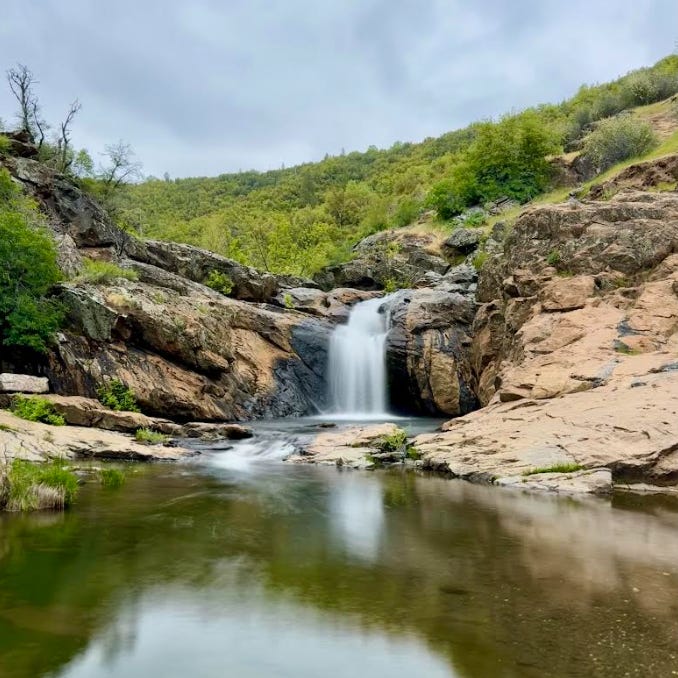
A serene, relatively undiscovered waterfall nestled in the forest.
📍 Location: Off of Highway 120, near Groveland (Northwest entrance)
🥾 Distance: 2 miles out & back
📈 Elevation Gain: 400 ft
🕰️ Time Needed: 1–1.5 hours
👶 Kid-friendly: Yes, but note there is a 15-20’ scramble required to get down to the swimming area (which is also the prime waterfall viewing spot)
🐶 Dog-friendly: Yes on leash
🚗 Parking: Small dirt pull-off area with space for ~8 cars
💡 Pro Tip: Early morning is the best time to visit before the crowds. The trail is shaded and cool, but you'll want to bring bug spray for the summer months.
For dinner, head to The Grove House in Mariposa—this gastropub’s cozy vibe and elevated menu make it a small-town gem.

Day 2: Swinging Bridges, Secret Pools & Forest Magic (Integrated map below)
Before heading to your first trail, swing by Cinnamon Roll Bakery & Café in Mariposa for coffee and a homemade cinnamon roll that’s big enough to share (but you won’t want to).

🚿 Hike 1: Lower Chilnualna Falls Trail

📍 Location: Wawona area
🥾 Hike Distance: 0.4 mi out & back (option to continue 4+ miles to Upper Falls)
📈 Elevation Gain: 140 ft
👣 Trail Type: Easy
🐶 Dog Friendly: No
🚗 Parking: Small paved area at trailhead
💡 Pro Tip: If kids want to explore more, scramble a bit further up for a second waterfall and larger pool (lot’s of elevation to do this).
🌉 Hike 2: Wawona Swinging Bridge Trail

📍 Location: Just down the road from Chilnualna Falls
🥾 Hike Distance: 0.75 mi round trip
🅿️ Parking: Dirt lot fits ~20 cars
👶 Trail Type: Super kid-friendly (flat and easy!)
💦 Bonus: Swimming and wading in summer
🌸 Best Time: Visit in spring for wildflowers
💡 Pro Tip: After crossing the bridge, take the left trail for a peaceful riverside stroll.
💧 Hike 3: Lewis Creek Trail – Red Rock & Corlieu Falls

📍 Location: 7 miles south of Yosemite's South Gate (on Hwy 41)
🥾 Hike Distance: 2 mi round trip to Corlieu Falls · 3 mi round trip to Red Rock Falls
⏱️ Time Needed: 15–30 min (Corlieu) · 1–2 hours (Red Rock)
📈 Elevation Gain: 300 ft
🐶 Dog Friendly: Yes (on leash)
🚗 Parking: Small lot fits ~12 cars, plus overflow
⚠️ Heads Up: The bridge to Red Rock washed out—there’s a DIY log + rope crossing in its place. Avoid after rain or with young kids.
🔁 Trail Split Tip:
👉 Right = Corlieu Falls (steep but quick)
👈 Left = Red Rock Falls (longer but gentler)

The “Bridge” required to start the journey to Red Rock Falls. I did not have time to attempt on this trip!

🏕️ Wrap-Up: The Perfect Yosemite Basecamp
There’s a reason families keep coming back to Mariposa County — and if you stay at AutoCamp Yosemite, you’ll see why. It’s the perfect basecamp for both adventure and chill time, just outside the gates of America’s most iconic national park.
And the best part? While everyone else is standing in line at Tunnel View or Yosemite Falls, you’ll be climbing into secret caves, crossing swinging bridges, and soaking your toes in waterfall pools most visitors never find.
📍 California’s best of the best trails, including all of these, are on my custom map here.
Have a favorite hidden Yosemite spot? Let me know! And don’t forget to share this with a friend!
Map Summary Day 1: Google Maps (←pre-loaded link)

Map Summary Day 2: Google Maps (←pre-loaded link)

Happy Trails!
- Dan
Thank you, you’re the best!
Thank you!!